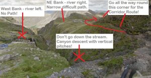
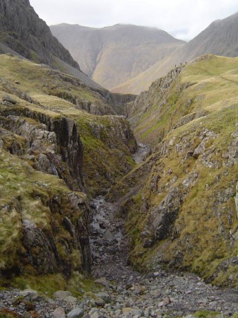
Piers Gill is the deep cut gill which the Corridor Route crosses 200m after leaving Lingmell Col on the descent from the Pike. Piers Gill, itself, is a ‘canyon’ descent with several short pitches and one longer one; do not attempt to walk down the bed of the stream!!
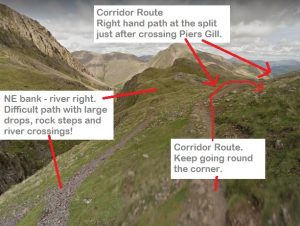
There is a path on the NE( river right) bank. This path has very steep sections next to large drops into the gill – there have been several serious accidents in this area in recent years. Also, after a bad rock step the path crosses Greta Gill which can be hazardous or impossible if the weather is wet. If you find yourself in difficulties on this path then, it is probably safer to, turn around and retrace your steps to the corridor route.
There is no path on the W ( river left ) bank and indeed there have been fatalities in this area in recent years.ÂÂ
If you intend to descend by the Corridor Route then make sure that you go all they way round the corner of the Piers Gill crossing and actually slightly uphill to follow the path, well away from Piers Gill, which leads down to Styhead.
If you are at the head of Piers Gill and want to go to Wasdale via Hollowstones then, if you face downhill looking down the stream, Wasdale is uphill to your left. Follow the Corridor route, south west, over Lingmell Col, but continue on and down into Hollowstones rather than following the Corridor Route up the Pike.
One further point, there is no mobile phone coverage in the area around the gill!
Top of Piers Gill.

Just after crossing the top of Piers Gill the path splits – take the right hand branch for the Corridor Route. The Corridor Route goes uphill slightly before continuing to descend to Styhead. There is a rock step on the Corridor Route at the head Greta Gill (Greta is the next major stream crossing on the way down after Piers Gill). Once across Greta Gill do not follow what appears to be a track down the north bank ( river right )of Greta Gill. This track is unconsolidated and has steep drops into Greta Gill; it isn’t the continuation of the Corridor Route.

